Modify Topo/Bathymetry
This tool allows modifying the elevation values of a topography/bathymetry raster in a given area. For example, to reduce the elevation of a mountain range that used to be lower in the past. To infer this information a literature review can be performed and various datasets can be used (paleoelevation, thermochronology, fossil, etc...) some of which are available in the Terra Antiqua data bundle or on map.paleoenvironment.eu.
A vector mask contained in a shapefile must define this area. This mask can be easily created using standard tools in QGIS (see How to table and QGIS manual chapters 13, 14 and 15). If that file contains several polygons, they will be treated at once, unless you specify otherwise. The topography modification is either performed by linearly rescaling the existing elevation between a given maximum and minimum, or applying a mathematical formula of your own. These parameters are to be defined in the parameters window.
In effect, the tool first rasterizes the vector masks using functions from the GDAL library. The resulting raster contains 1s inside polygons and 0s outside them. These raster masks are then used to select pixel values that need to be modified. Each pixel’s elevation value is then changed with methods mentioned above. The formula, elevation ranges to be modified, and other parameters can be entered directly in the dialog (step 3). They may also be retrieved from the attribute table of the input vector shapefile (when preparing shapefiles, it is possible to include this data in the attribute tables, to learn more on attribute tables and shapefiles see QGIS manual chapters 13, 14 and 15). The modified raster is then saved as a new raster and added to the current QGIS project as a new layer.
It is advised to use this tool on the paleoDEM after setting the paleoshorelines if the regions to be modified are near or overlap coastal areas that may be affected.
Step by step
Link to the VIDEO illustrating these stepsLink to the VIDEO about the combined use of Modify Topo / Bathymetry and Create Topo / Bathymetry
-
Click on the icon
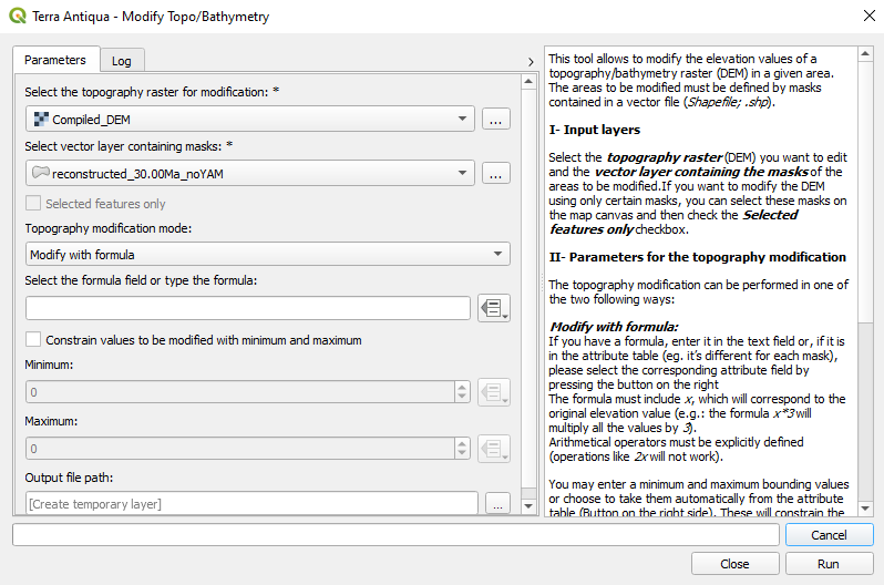
Select the DEM you want to modify.
Select the shapefile containing the polygons to be used as masks. If you do not want to use all the polygons, check the box to use only the selected features. For this you need to select polygons on the map canvas of QGIS. Choose the linear rescaling provided with the tool or if you want to use a formula of your own.
- Rescale with final minimum and maximum values: this is the standard method. You can enter the final minimum and maximum elevation values, between which the topography values will be rescaled. Alternatively, you can choose to retrieve them from the attribute table of the shapefile if they have been previously entered. This can save time if the final maximum and final minimum are different for each polygon.
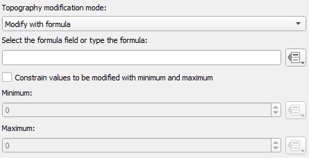
- Modify with formula: you can either type a formula in the text box, or choose to retrieve it from the attribute table of the shapefile (if it is different for each polygon/mask). Additionally you may choose to constrain the elevation values the formula is going to be applied to. (see screenshot below)
To retrieve data (minimum elevation, maximum elevation, and/or formula) from the attribute table of the shapefile use this button

Retrieving the data (minimum elevation, maximum elevation, and/or formula) from the attribute table of the shapefile saves time especially if the values are different for each polygon. To enter data in the shapefile see QGIS manual chapters 13, 14 and 15.

The formula must have a specific format. Make sure you follow the instructions from the text on the right part of the window. The algorithm recognizes all mathematical operators. For the full list see the numpy website.

If you intend to use different modification methods for each mask in your shapefile, you will need to use this tool several times, each with one modification method. The first output will then serve as input for the second, etc.
In this case, you will have to select the option to use only the selected features (polygons). For each run you need to select the masks you want to use from the shapefile and tick this box

For instance:
3 types of modification:
1 in masks for large areas (continental scale) to be linearly rescaled,
1 in masks for smaller regions to be modified with a formula,
and 1 in masks for smaller regions to be linearly rescaled.
Run the tool 3 times: - 1st run
Input: DEM to be modified + shapefile with masks of the areas to modify having selected only those corresponding to large areas.
Output: DEM with modifications to the large areas
- 2nd run
Input: DEM with modifications to the large areas + shapefile with masks of the areas to modify having selected only those corresponding to smaller regions to be modified with a formula.
Output: DEM with modifications to large areas and smaller areas modified with formula.
- 3rd run
Input: DEM with modifications to large areas and smaller areas modified with formula + shapefile with masks of the areas to modify having selected only those corresponding to smaller regions to be linearly rescaled.
Output: Final DEM with all modifications.
- Choose the Output file path, and click Run.