Compile Topo/Bathymetry
The purpose of this tool is to create a raster that combines the topography and the bathymetry at a given age of reconstruction.
To do this you will simply select the input raster files with the Bedrock topography, the Bathymetry and in some cases the Ice topography (step 1 below).
Bedrock topography was previously obtained by cutting modern topography and rotating this according to the tectonic rotation file to the targeted age.
If there are gaps in the overlying layers, some of the underlying layers may appear in those gaps and generate artefacts. For example, the Andes have many tectonic blocks that are separated by gaps in the past paleoreconstructions. In those gaps some of the underlying bathymetry may appear near the continent-ocean boundary.
This will result in unrealistic deep ocean bathymetry in the gaps between the otherwise mountainous tectonic blocks of the Andes. To remove these artefacts we have developed several tools (see Remove Artefacts![]()
The algorithm distinguishes between the different types of data being collected with the help of continental blocks as vector masks. When this mask layer is supplied, the user will assign it to the corresponding raster file (step 4 below).
Note that this compilation will be done to the entire file. If you want to use it only in a limited area, you can export to a new file a rectangular section of the map with QGIS (in the layer window right click on the raster file name and choose “export > save as...” to select the rectangular area). Then run the tool on this new file. However, if you have global topo/bathymetry data, it is easier to first run this tool globally and then cut a rectangular section as described above.
Step by step
Link to the VIDEO illustrating these steps-
Click on the icon
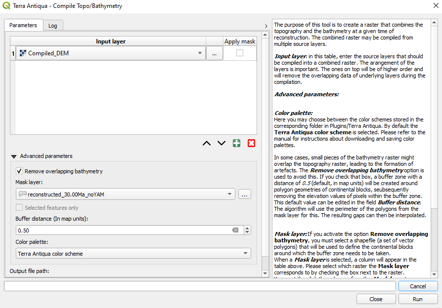
Select the raster files you want to compile. These should correspond to the topography and the bathymetry (and as the case may be, the ice topography).
If there are gaps in the topography creating artefacts due to the underlying bathymetry, you may choose to Remove overlapping bathymetry in the Advanced parameters. The polygons entered as a Mask Layer are used as a guide for this part of the process. In addition, a buffer (whose size can be edited under Buffer distance) of “no data” values will be created along the edges of those polygons.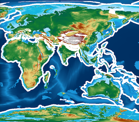
When you enter the Mask Layer, select which layer the polygons correspond to in the column Apply mask.
- Choose the Output file path, and click Run.
The layers will be combined in order (the layers on top of the list will remove overlapping data of underlying layers). Use the buttons at the bottom of the list to add, remove, and arrange rows:


![]()
![]()

It is recommended to use the polygons corresponding to continental blocks as mask layers for steps 3 and 4.